Authored by: Willie Chen
"They were lost, but not forgotten."
Liou Clan in Sigang village of Tainan had a recent rediscovery to these tombs of their early arrivals in Taiwan. These were buried deep at that particular ground level of three centuries ago when their ancestors traveled across the Taiwan Strait and defeated the European trade superpower which first put Formosa into the world map. The story of their first ancestors long resting at their current neighborhood near the lost grand lagoon is passed down for generations. It was only until the Liou Clan of Sigang's commitment to carry out an archaeological dig after forming their own clan society that their former glory is revealed and their first arrivals are once again lit under the sun.
Taiwan Old Family paid a visit in early 2021 to see how the local Sigang Liou clan transformed their ancestor's resting place into a treasure trove of the island nation.

The Sigang village did not stand what is seen today as an inland village but a marina harbor which witnessed the upheaval of change of powers in 17th century.
Why these Liou's early tombs were lost?
Who they were in the Taiwan's settlement history?

Tombs of Early Chinese Arrivals to Formosa
The first systematic Han immigration from lands of China to island of Formosa took place during mid 17th century led by Lord Koxinga, Cheng Chenkung, a Ming Chinese Empire loyalist took Formosa from 17th century Dutch VOC's as the military base in order to restore their Ming administration after Manchus invasion. There were already certain Chinese labors and farmers deployed by Dutch VOC (Dutch East India Company) for sugar cane and rice agriculture during Dutch Formosa in early 17th century. In 1652 a rebellion led by disgruntled Ming Chinese farmers deployed by the Dutch Formosa also lead to another fortification of Fort Provintia at coastal area inside the lagoon.

The recent studies incorporated by the University of Leiden in Netherland and the Academia Sinica Taiwan have revealed that the land and house owners in the first urban market town of Fort Zeelandia, the present day Anping district of Tainan that significant numbers of houses were owned by the Tan people, aka Chinese from Ming Empire, and other merchants of southeastern Asia origins. It is clear that number of Han Chinese people already arrived at Formosa before Lord Koxinga's crew to revert Manchu Chin. However it was little known whether they eventually went back to China from where they came from. It was also little known whether those actually left their burial sites in this land as ancient Chinese had a history of taking good care of ancestors with tombs.

Those came with 17th century Lord Koxinga actually stayed on in Formosa predominately in the area surrounding the current day Tainan which was a trade base initially established by Dutch in a similar status to New York in the North America. Dutch VOC over Formosa ended at year 1661 and in the following year Cheng died at Tainan and subsequently the Ming Cheng's Formosa ended in 1683. Lord Koxinga and his son Cheng Jin(鄭經) first buried in Tainan but later in 1699 their tombs were brutally excavated and relocated back to Fohkien province by the order of Manchu Chin Emperor Kangsi. The last Ming royal family King Chu Shukuei (朱術桂) and his laddies also escaped to Tainan to attach with Lord Koxinga's fellows. In 1683, the last Ming royal family surrendered to the Manchus Chin and five noble laddies of King Chu killed themselves right at the eye of the King. These sacrifice ladies were buried at a graveyard near the royal palace in Tainan which was later repurposed as Temple of Five Concubines (五妃廟). This is the first Ming Chinese tomb being recorded in Formosa with a royal status with a significant Han layout burial site . The King Chu later killed himself at his palace and his first lady and infant son were thoughtfully buried elsewhere by their fellows. It was heard their real tomb is unknown but a hundred of clones of the Ming last royal tomb were created in order to confuse Manchu Chins. One of the cloned tomb was identified in modern day Kaohsiung as an empty mausoleum inscribing just their names.

Figure: Tainan's Temple of Five Concubines, one of the earliest and perhaps the only surviving Ming Loyalists tombs at Formosa. The Han style tombs with a raised central mount with nearly semi circular shape with two stretching arms is normally a typical style from Han funeral culture. Source: drawn by 王浩一 and 俠客文創
Ming loyalists Han style tombs in Formosa are mostly located in Tainan. Two ladies of Lord Koxinga Cheng Chenkung were buried in 1650s' in today's Tainan Nanshan Public Cemetery which were the rest places of the Ming Formosa Chinese immigrants to Formosa. Chen Yonghua (陳永華), a key admiral and cabinet of Ming Cheng's Formosa were buried in Tainan's Lioyin district during 1681 but sooner in Manchu Chin period that his tomb was also relocated back to Hohkien province China leaving part of the tombstone at the original site. While Manchu Chins took over Formosa from Chengs, most of key personnel's marks on the island were eradicated due to Anti-Manchu and Restoring Ming social movement. However, some of the Ming Formosa military families continued. There is a recently rediscovered Ming Chinese tombs through archaeological excavation their their descendant in the north of Tainan by the river. Their traces and their burial sites were pretty unknown for centuries due to the geological landscape has been shaped dramatically by rivers over the centuries.

Figure: Temple Front of Five Concubines in the photo by Tamrakar Paul Barclay in 1930's. The temple of the five ladies tombs was erected in early 18th century right in front of the tombstone which was first laid in 1682. Source: Collection of Digital Lafayette
It was until year 2001 Liou's family living in Sigang (西港) village of northern Tainan pursued a dig into the underground within their own neighborhood by the words passing down for generations that their earliest arrivals to Formosa were resting somewhere in their lands of rice paddies. The Liou's descendants living in Sigang was committed to locate them and and started to form a Liou Clan Society in 1984 researching their earliest traces in Taiwan and China and family trees grown from their earliest arrival Liou Dengkui (劉登魁).
According to Liou Clan Society's kept family tree book that their first ancestor in Formosa Lord Dengkuei was born in 1639 at Ming Chinese Dynasty and came along with those led by Lord Koxinga and passed away in 1714. There was yet no direct discovered archival evidence of which role in the Ming Cheng's Formosa government until 1683 but judged from the later rediscovered tomb that he might have a significant wealth and role to be affordable for such grandeur and scale of the graveyard.

 Figure: Dutch VOC first target station in the Ming Chinese territory - the Pescadores, an offshore island of Formosa but owned by Ming China since the 12th century. The map drawn by Dutch fort in Penhu during 1623 showing the Dutch's intention for an ideal marina bay laying their fort in the Far east region to compete with Spanish. Source: Austrian National Library Atlas Van der Hem V. XLI

Figure: The modern day Tainan was first perceived as the big lagoon and marina. 16th century Hokien Chinese called this island Big Marina as Tua Wan in Holo language and later used by European arrivals of the Great Exploration Age. The 1625 Dutch map of Formosa(PACKAN 北港社) primarily features in the details of such marina bay in the west coast as a first impression of modern day Taiwan. (Source: 臺江內海研究資料集 Taijiang Research Data Repository)

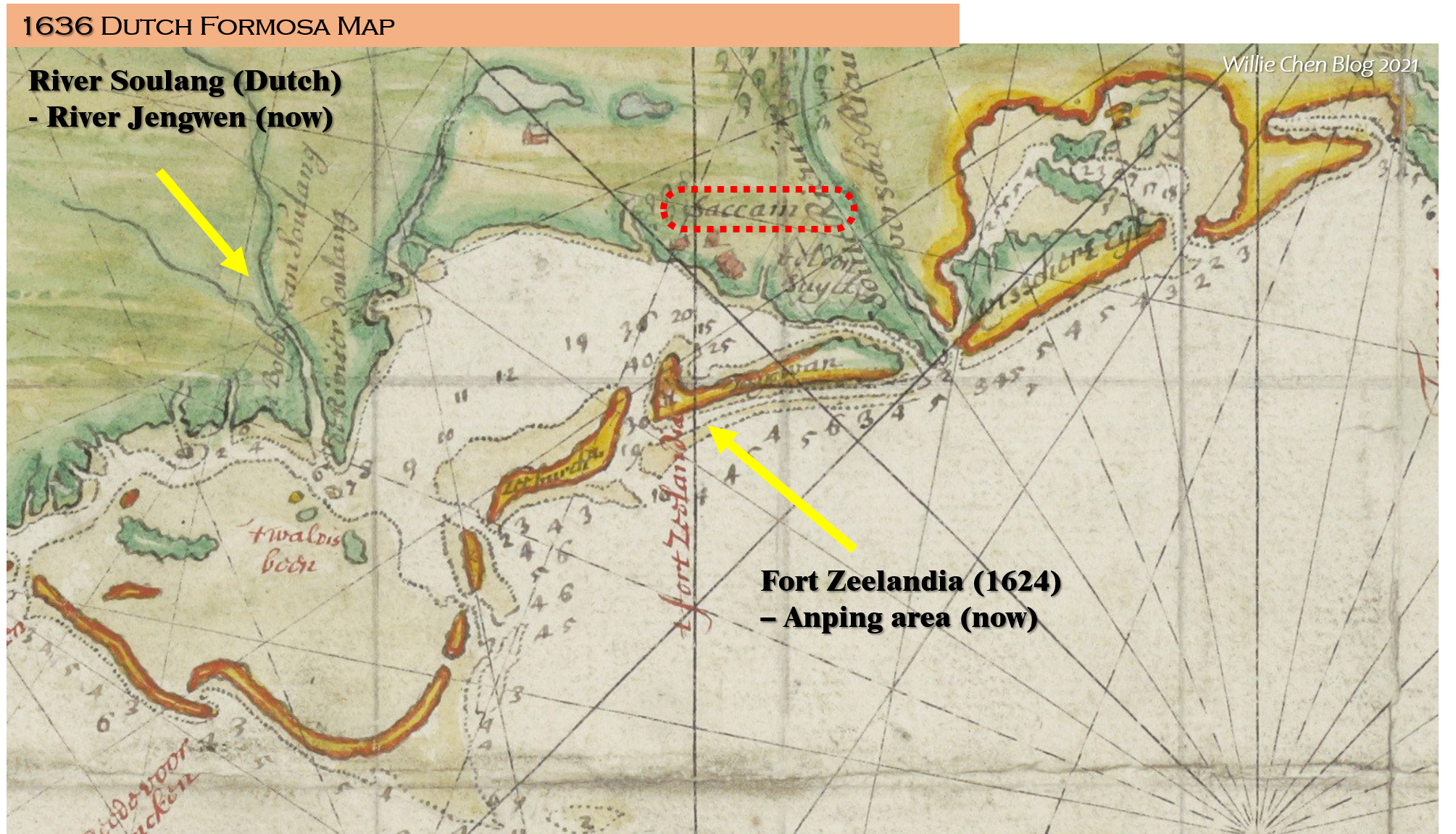 Figure: The island map of Dutch Formosa around 1636~1640 (FORMOSA EN DE EYLANDEN VAN PISCADORES). It clearly outlined the main administrative area of Fort Zeelandia, the inner land of Chihkan (Saccain) and river Soulang that goes into the big lagoon.
 Figure: The 2021 Google Map for Tainan area including two Dutch Forts, the river Jengwen (Soulang) and village of Sigang marked. The big lagoon between two former Dutch forts is gone. A new river Delta is spreading out of the river Jengwen compared to map created in 1636 by Dutch.


 Figure: Sigang village in 1759 map surveyed by Emperor of Manchu Chin Chienlung. The walled city of Taiwan Fu(Tainan) is well closer to the coastline with certain portion and lands but well bounded by lagoon and sandbanks. Source: National Palace Museum Taiwan


Figure: The Map of Formosa made by British Consulate around 1870 has cleared marked out the sand bars out of Fort Zeelandia can be in good condition for anchorage during winter (December to March). The Dutch Formosa period's lagoon inside the footstep of Fort Zeelandia became interlaced rivers. Source: Historic Maps of Academic Sinica Taiwan

Figure: Sigang village(west of Marina) is marked at Sigang street(西港仔街) as a Han normalized market town near the coastal area near the Jenwen river (曾文溪) in the map drawn for Taiwan when Taiwan became an independent province of China in 1878. At this map, the circle of Taiwan Fu(台南府) has been pretty much away from the coast. Source: 全臺前後山輿圖 Reading Digital Atlas of Academia Sinica with map source from the British Library

Figure: The Taiwan Fu(Tainan) and its surrounding areas surveyed by the Imperial Japanese government during its first year taking Formosa into its territory. Source: Historic Maps of Academic Sinica Taiwan
 Figure: Changes of the river Soulang(now Jengwen), being marked in orange, and the lost lagoon of Taioan throughout 16th to 19th century. Source: Taijing National Park


Figure: The 1921 revision map based on the 1898 Boroughs in Formosa made by the Japanese Formosa Government. The river of Jenwen is clearly in a different route than the version in 1898 in terms of the Liou village as a satellite village of Sigang market street town. Source: Historic Maps of Academic Sinica Taiwan

Figure: The modern map and location of Liou's mansion borough of Sigang market town in 2021. It remains an area of flat lands and rice paddies.


Figure: The tome 1 seen above the ground. Typical shape with a central raised mount like a turtle and an open arm layout.

Figure: Stone tablet erected to give an account of what this historic tomb came from the first arrival of Lious in Tainan during the years of Lord Koxinga progressing to Formosa.

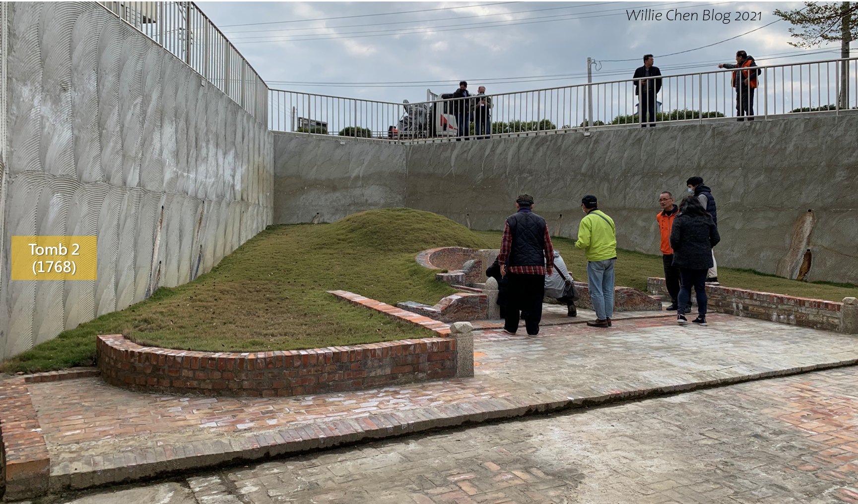
Figure: Tomb 2 seen from the ground level. It shares a similar size of the first generation Liou in Taiwan but still with a much significant scale than most commoner's tombs in Tainan.

Figure: Stone tablet erected in early 2019 to give an indication of the personnel in this site.

Figure: Tomb 2 of Liou in Sigang with a much ornate tombstone and fabrics as this was consecrated for the lady.
 Figure: The Sigang's Liou Clan Hall is to be consecrated behind the rediscovery site of their Liou's generation to Taiwan.
 Figure: The colorfulness of the fruit dish in Sigang village of Tainan, after we were treated at a local restaurant through the courtesy of Liou Clan of Sigang. The dish resembles the rich of diversified of the local produce and perhaps a gift from the lands enriched by the flooding river.
See also:

Figure: The grandeur and entire layout of tomb of Liou's first arrival Liou Dengkui to Formosa seen from above.
A successive archaeological digs were carried out by the team from National Chengkung University and finally two tombs were revealed in February of 2001 and they were all sunken almost 4 meters below the current ground level. One of the first Liou arrival Liou Dengkui tomb consecrated in year 1714 and another tomb was Liou's third generation in Formosa Lady Chen installed during 1768. Both tombs were virtually buried in the same area with similar size of a hundred square meters and sharing similar deep down to the ground level.
But how they were all underground? It all began how the name of Taiwan came from.
The Lost Lagoon which made Formosa as Taiwan
The archaeological dig to these two Ming loyalists tombs at Sigang village actually unfolded a striking changes to the past landscape of where the three centuries ago tombs were buried around the modern day Tainan. Tainan was historically the capital city of Formosa until 1884 and was called Taiwan Fu(臺灣府), literally the county of Taiwan.
When the Europeans came over Formosa around late 16th century, the island was still given a name of Formosa instead of Taiwan. It was until the Dutch VOC had a desire to take Pescardores archipelago (the current day Penhu isles) as a temporal station as their seat on the Far East trade route, the push back from the Manchu Chin that Dutch VOC should go further away to the bigger island behind with a better marina that was not a territory owned by Manchus.

The occupation of Penhu island by the Dutch VOC was short and soon after that they were defeated by the Ming Chinese. The Dutch then turned their eyes on the bigger island which they had a little knowledge of it. What they knew then was a perfect marina, a big bay (Groote baye), formed by the lagoon according the Chinese sailors of the region. The big marina in the Holo speaking population in Hokien province is Tua Wan (大灣) or Dai Wan. This was thereafter the name of Tayouan (Teijouan, Teowan) being marked on several of the Dutch map for the bay area. This is how the modern day Taiwan came from. The big marina, big lagoon, big bay was sooner the base taken by the VOC.

Figure: The modern day Tainan was first perceived as the big lagoon and marina. 16th century Hokien Chinese called this island Big Marina as Tua Wan in Holo language and later used by European arrivals of the Great Exploration Age. The 1625 Dutch map of Formosa(PACKAN 北港社) primarily features in the details of such marina bay in the west coast as a first impression of modern day Taiwan. (Source: 臺江內海研究資料集 Taijiang Research Data Repository)
The Dutch VOC successfully took over the big lagoon of the island in 1624 and started investment of fortification and streets for trade. On the edge of the sandy peninsula that overlooks the big lagoon and the sea, the Fort Zeelandia was laid to house their administration. The area is now the modern day Anping district of Tainan city. That fortification and nearby areas were recorded by the snipping and coveted Spanish in 1626 with a map called "DESCRIPCION DELPVERTO DELOS OLANDESES ENYSLAHERMOSA" in which it clearly depicts the geographic landscape of the big lagoon and mountains, the fortifications and their distribution, the villages of various tribal and racial groups. This is perhaps the earliest map for modern day Tainan which comes from the big lagoon. The major modern day Tainan development now is right across the lagoon instead of the Anping (安平) area where the Dutch VOC fort Zeelandia was put up. The Dutch started to investment civic plan across the lagoon in 1652 where they started off another Fort Provintia (普羅民遮城), a new province on Dutch Formosa. The Fort Provintia and nearby area is later the seat of governmental administration since the Ming Cheng's from 1661. The Fort Provintia was later given name as Fort Chihkan (赤崁樓) due to the areas originally resided by the Formosa's Austronesian tribe of Chihkan.

Figure:The Map of Dutch Fort Zeelandia Fort on the sandbar of the lagoon, created by Spanish cartographer Pedro de Vera in 1626 is the earliest portrait with landscape and the tribal distributions inside the big lagoon of former Tainan before the lagoon was later filled. Two forts were laid during Dutch Formosa and survived to the modern days. (Source: Wiki Common)
The Dutch VOC also revised their 1625 PACKAN map into more detail geological information at later years when they gradually gaining controlled the island. A newer version of PACKAN map was released in 1636 to 1640 and more details were filled. In that version, the major river Soulang go into the lagoon at Tainan was revealed. This river is the modern day river Jengwen (曾文溪) where Sigang village is very closer to it.

Compared to the 1640 Dutch map of Formosa to the present day (below Google Map), the larger part of the 17th century lagoon between two Dutch Forts were diminished by rising lands and the river delta has grown out from the estuary of river Jengwen (Soulang in Dutch Formosa time).

The river Delta out of the estuary Jengwen (Soulang) and part of the sandbanks of the former lagoon is now a natural parkland with a national listed status, the Taijiang National Park. Numerous studies have been sought into what changes to the geographic landscape have been made over the latest centuries. The village of old Sigang (West of the Lagoon) actually witnessed how the lagoon disappeared and become replaced by rising land.

Figure:The evolution of the coastline from 1680s Taiwan. Source: Wu Chienshen, National Cheng Kong University, Taijiang National Park 2012.
Evolution of Soulang River, Village Sigang and the lost Lagoon
Sigang village, originally a Chinese location name literally refers to west of the marina and lagoon, or harbor of the west Tainan city, is seen significantly drifted away from the coastline. Sigang was not identified by any of the earlier Dutch map as it was primarily set up by the Han Chinese immigration during the Ming Cheng's take-over of Formosa (1662~).
According to the local council of Sigang, the name first appears in the Ming Chinese Chulo County Records (諸羅縣志) published in 1717 and obviously this town's existence predated the year 1717.
In this county record, it was attached with descriptions for why this town matters.
「西港仔港、海叉、有港,小舢板頭到此渡客,並載五榖、糖菁貨物。港水入至安定里西保止。港口有魚塭。」
Sigang bay market town is located with a harbor interlaced with the sea. Ferries start here and with a range of shipping goods like grains and sugar. The bay water goes into the Angding borough, the village, with the fishing pond near its bay.
There is a Maritime Godess temple in the Sigang village and is said to be consecrated during Ming Cheng's Formosa when Lord Koxinga launched his military campaign to the Dutch VOC. His troop ever stationed at Sigang area and this is how the temple is based on.
The name of the Sigang marina village and port market town gradually appear from the royal maps created for Formosa since the early 18th century. However, Ming Cheng's Formosa remained a rather mythical period though its short length in history but likely archival records being destroyed by the later Manchus' siege. Maps can be studied were primarily those European cartographers and the imperial maps made during Manchus Chin's reign.

Figure: The village of Sigang have been first clearly marked as a village in the map created in the first half of 18th century during Manchu Chin during Emperor's Youngjen. The walled city Taiwan Fu(Tainan) is adjacent to the lagoon with western section of wall blocking the lagoon. Source: 雍正台灣汛防圖, Reading Digital Atlas of Academia Sinica with map source from the British Library
Figure: Sigang village in 1759 map surveyed by Emperor of Manchu Chin Chienlung. The walled city of Taiwan Fu(Tainan) is well closer to the coastline with certain portion and lands but well bounded by lagoon and sandbanks. Source: National Palace Museum TaiwanThe Sigang village (西仔港庄) shown in 1735 and 1759 Formosa map during the imperial geologic survey that it was marked south of estuary of the river Wangli (灣裡溪) which was called Soulang(蕭瓏) during Dutch Formosa. The upper stream of river Wangli also changed dramatically within that quarter century period. The walled city of Taiwan Fu grew from 1735's half walled circle into a full walled city in 1759.
The walled city of Taiwan-Fu is built primarily around the Dutch Fort Provintia (aka Fort Chihkan) area which was adjacent to the coastline to the lagoon during the 1626's Spanish map created to spy Dutch VOC on Formosa. Over centuries, the lagoon shrinks in size and gives way to urban development.

Figure: Map of the lagoon at the modern day Tainan can still be identified with sandbanks and isles populating at the lagoon in the 1864 map sketched by British consul-Swinhoe. Swinhoe's sketch map of Formosa has some serious mistake making tag for the place name with about 15 km away (
Mapping Asia: Cartographic Encounters Between East and West, by Martijn Storms ). The Haccam should be the Taiwan-Fu. The Fort Zelandia should be north of the long sandbar. Swinhoe's 1864 map has two reference sources from Dutch and America made it at 1856. Source: Historic Maps of Academic Sinica Taiwan

Figure: The Map of Formosa made by British Consulate around 1870 has cleared marked out the sand bars out of Fort Zeelandia can be in good condition for anchorage during winter (December to March). The Dutch Formosa period's lagoon inside the footstep of Fort Zeelandia became interlaced rivers. Source: Historic Maps of Academic Sinica Taiwan

Figure: Sigang village(west of Marina) is marked at Sigang street(西港仔街) as a Han normalized market town near the coastal area near the Jenwen river (曾文溪) in the map drawn for Taiwan when Taiwan became an independent province of China in 1878. At this map, the circle of Taiwan Fu(台南府) has been pretty much away from the coast. Source: 全臺前後山輿圖 Reading Digital Atlas of Academia Sinica with map source from the British Library

Figure: The Taiwan Fu(Tainan) and its surrounding areas surveyed by the Imperial Japanese government during its first year taking Formosa into its territory. Source: Historic Maps of Academic Sinica Taiwan
Into the second half of 19th century, Formosa was once again under the western eyes through the port opening under Manchu Chin treaty with numerous western superpowers particularly Britain. Earliest map might be carried out by America during 1854 while most comprehensive map were surveyed by British consuls and their explorers to Taiwan including those new Church evangelists. Comparing the maps created by British in 1864 Swinhoe and 1870, the large lagoon was no longer available but being replaced by various marina bays around Taiwan-Fu. Particularly in the 1870 map, the anchorage timing for Tainan marina was specified during winter season and suggesting rising lands at the river delta and the former Dutch Formosa's lagoon. 19th century British created maps largely based on the 17th century Dutch VOC while certain names was incorporated with Chin Chinese.
Further until the map in 1878 created by Japanese eyeing on Formosa, the Sigang village bay is marked north of the river Soulang (Jengwen), compared with most earlier version during Chin China that Sigang port village and market town were all south of the main river?

According to the historic local county records, there were four major detour events of the river Soulang in recent three centuries due to the flooding and mudslides after tropical rain and storms from the central Mountain Ranges of Taiwan. These took place in year 1823, 1871, 1904 and 1911. The one in 1823 dramatically filled the lagoon which the Taiwan-Fu county office is located next to it. It also detour the river of Soulang and the market town of Sigang has been relocated to the north of the river as in today.
Sigang's Ming Loyalist Tombs, A Thermometer to see the rise and fall of Soulang river
The Sigang village located at the edge of the lost lagoon and in close proximity of river Soulang seems a thermometer to watch how lands rise and fall in Tainan. Most of the buildings we can discover in this area were rebuilt after the early 20th century and among them the oldest building, Liou's Historic House at Liou Clan Borough with its first foundation stone traced back to early 1860's but rebuilt in first half of 20th century with terrazzo and bricks. The house was laid by Liou Biennan(劉楩楠), the direct and later descendant of first generation Liou Dengkui whose tomb was rediscovered through digging through the Liou's neighborhood.

Figure: The main Liou's family house(西港劉厝) in Liou's mansion borough(劉厝里) in Sigang market town rebuilt in early 20th century during Japanese Formosa period. Source: 吳基烈

Figure: One of the oldest above ground structure, the farmhouse, sitting between two unearthed Liou's ancestors tomb has a distinctive feature of 1940's redbrick. It is suggested the area's development took place in less than 70 years.
The Liou's Clan Borough (西港劉厝村) is located in the outskirt of Sigang market town and is predominately resided by descendants of the unearthed historic tombs and the whole settlement is named after the Liou. Now the entire Signag village and Liou's Clan Borough is located north of the river Jengwen(Soulang). The earliest precise map for this market town was made in 1898 by the survey of Japanese Formosa government. However, when this comes to do a comparison to the modern day Google map in 2020 that the river belts the Sigang market town has changed over a century and perhaps it is still expecting changes in the future.

Figure: First precise map created for Taiwan in 1898 for boroughs in Formosa with surveys done by Japanese Formosa government. Liou's village is part of the Sigang market street town. Source: Historic Maps of Academic Sinica Taiwan

Figure: The 1921 revision map based on the 1898 Boroughs in Formosa made by the Japanese Formosa Government. The river of Jenwen is clearly in a different route than the version in 1898 in terms of the Liou village as a satellite village of Sigang market street town. Source: Historic Maps of Academic Sinica Taiwan

Figure: The modern map and location of Liou's mansion borough of Sigang market town in 2021. It remains an area of flat lands and rice paddies.
Two unearthed Liou's tombs are located inside the current Liou's Clan Borough but more in the outskirt direction toward the see and river. The late 19th century Liou Clan historic house as main lodge is located at the other direction of the Liou Clan Borough and it might suggest that the late 19th century rebuild might have picked a site away from the flooding zone and known ancestor's tombs.
Tomb 1 rediscovered was consecrated in year 1714 serving the first generation and the tomb 2 rediscovered was consecrated in year 1868 for the lady Liou who was a grand daughter in law of the first tomb 1. It was suggested there might be more tombs covered underneath the rising lands for two centuries. The Liou's Clan Society does not continue to uncover more of them in the near future due to the current conservation difficulty to give great care of the unearthed tombs sitting below the ground level line and prone to seasonal flooding that might take place as how they were first buried century ago.

Figure: The locations of two recently unearthed tombs in Liou's Mansion Borough(劉厝里)
Due to the rare and earliest Han Chinese buried on the island, the local council and the Liou Clan had once submitted to the cultural authority to gain a status as a national listed heritage status during early 2000's. However, there are voices from the descendants that they would like to move these underground tombs from the flooding zone that could trap their ancestors. This also damage the authenticity of being one of the earliest Han tombs on the island and the heritage status have not yet been given.
However, due to the opulent amount of unearthed artifacts and leveled unity of the Liou Clan, they are in a motivated to build a Clan hall that can house their people heritage and the region.
TOMB 1 consecrated in 1714
Figure: Taiwan Old Family extended the clan heritage network to Tainan by stopping over the Sigang's treasure trove - the underground tombs of Ming Loyalists at Taiwan. Source: Taiwan Old Family
Figure: Tomb 1. The Sigang's Liou Clan Society director Liou Wenjia (劉文加) gave an orientation to Taiwan Old Family about the restored tomb 1 of their first generation at Taiwan and how this was rediscovered through the memory passed down for generations.

Figure: The tome 1 seen above the ground. Typical shape with a central raised mount like a turtle and an open arm layout.

Figure: Stone tablet erected to give an account of what this historic tomb came from the first arrival of Lious in Tainan during the years of Lord Koxinga progressing to Formosa.
TOMB 1 consecrated in 1768

Figure: Tomb 2 seen from the ground level. It shares a similar size of the first generation Liou in Taiwan but still with a much significant scale than most commoner's tombs in Tainan.

Figure: Stone tablet erected in early 2019 to give an indication of the personnel in this site.

Figure: Tomb 2 of Liou in Sigang with a much ornate tombstone and fabrics as this was consecrated for the lady.
Sigang's Liou Clan Hall
At the time of Taiwan Old Family paid a visit to Liou Clan Society in Sigang in early 2021, the Liou's Clan Hall is built underway right behind the unearthed tomb of their first generation to Taiwan. Once it is completed, this Clan Heritage center might play a focal point for the local clan community and annual clan ritual and events but also boost the local tourist traffic by giving combined tour to the nearby early Chinese tombs to Formosa and how the history of Taiwan was transformed through the lost lagoon and the river nearby which is in a constant transition from the past into present and future.


See also:
Earl's Tomb of Wang Delu - The Largest Imperial Burial Site in Taiwan 台灣島上最大規模古墓-國定古蹟嘉義太保『王得祿墓』
Reference:
1. 臺南市西港區公所, 發現西港(四)劉厝古墓, https://www.sigang.gov.tw/cht/plan/showinfo-11.html, Accessed in 2021-Jan
2. Sigang District Office, Tainan City, Local attractions - Liou house tombs, https://www.sigang.gov.tw/en/plan/showinfo-38.html
3. Apex Cheng, 薰風南來--- 西港 劉家古厝, https://blog.xuite.net/apex.cheng/wretch/224344579, 2014-06-29
4. 曾文溪 on Wiki, https://zh.wikipedia.org/wiki/%E6%9B%BE%E6%96%87%E6%BA%AA#cite_ref-%E8%87%BA%E5%8D%97%E6%B2%B3%E5%B7%9D_2-0, accessed in 2021-02
5. "一場風雨 河川改道", 921 Earthquake Relief Foundation, http://www.taiwan921.lib.ntu.edu.tw/mypdf/bkfaceA02.html
6. Taijiang National Park, 地理變遷, https://www.tjnp.gov.tw/History/Geography.htm, accessed in 2021-05
7. 郭弘斌, 鄭氏父子的陵寢, https://www.taiwanus.net/history/2/53.htm, TaiwanUS.net, accessed in 2021-05
8. Wiki Common, 台灣塚墓列表, https://zh.wikipedia.org/wiki/%E5%8F%B0%E7%81%A3%E5%A1%9A%E5%A2%93%E5%88%97%E8%A1%A8, accessed in 2021-05
9. 王浩一, 漫遊府城:舊城老街裡的新靈魂 Old Bricks Old Trees II, 心靈工坊文化事業股份有限公司, 2012
10. 翁佳音, 台江國家公園及周緣地區人文歷史調查及保存之先琪研究, https://np.cpami.gov.tw/filesys/dl/type1/126/2137_d0865a42bc1feb155a296a0c132a1884.pdf, Taijiang National Park, 2010-12.吳建昇, 台江地區文史資源調查及應用規劃研究(三)竹筏港歷史調查與台江文史導覽書籍編著計畫, https://www.tjnp.gov.tw/FileDownLoad/Result/20200515141053952997.pdf, Taijiang National Park, 2014-02
Comments
Post a Comment