Sek-Khau once a Little Suzhou in 19th century Taipei and the birthplace for first stamp of Formosa 【錫口】北台灣小蘇州, 台灣首張郵票發生地
Author: Chen Guo Yuan Willie
In 1885, the Canadian missionary George LeslieMackay, the founder of the Presbyterian missionary in northern Taiwan, had claimed to rebuild several of his churches in Taipei after they were devastated by the revenge Han-Chinese during the upheaval of Sino-French War that also took place in the Northern Taiwan. One of his rebuilt churches is located in middle section of the upstream River Keelung at port of Sek-kháu (錫口), a name from the former low-land plain tribe inhabited here for thousands of years. This is the first time when this small town became largely documented in the world history.

Figure 1:
Left: The 1885 rebuilt Mackay church in Sek-kháu (錫口禮拜堂) in post 1930s with a dominated front spire that
was quite an important style in the colonial period of the North America. The spire was probably still the original one while the main nave refurbished. Source: TW
Memory Phot Archives.
Right: The dominating Gothic spire of Mackay rebuilt church in Songshan survived through 1960s when the narrow street at the front became a night market since 1980s. Source: 許英峰先生老照片. 中華日報

Figure 1a:
Left: The rebuilt Mackay church in Sek-kháu before the central nave got a rebuild in 1930s. Source: Elder John Lai's Archives.
There were little information about this name and place even in Chinese archives as this name were later became Matsuyama (松山) in 1920 when Taiwan was taken by Japan since 1895. Japanese immigration from Shikoku (四國) prefecture came to settle and discovered a resemblance from the landscape of Matsuyama, their home town. The original tribal name of the place "Sek-kháu" means the landscape of where the river interlaced and twisted which was also just like it was seen in Matsuyama.

Figure 2: The Map of the Taipei in the Matsuyama, drawn by American Air force
in 1944. The town of the Matsuyama is near where the twisted section of the
river of “KIIRUN” (River Keelung).

Figure 3:
Above: An early image of the River Keelung around town of Sek-kháu in early 1910s-1930s. The Market town can be
seen south of the river. (source: Songshan Elementary School)
Below and Background: Image of the entire Matsuyama town captured after
the air raid by US Air force in 1944. The arrow indicates the above 1920-1930s image
seen through the river. Source: US Army
The time when the Canadian missionary
Mackay came to northern Taiwan in 1870s, most of the places in the northern
Taiwan were still predominately populated with plain tribal groups. Han-Chinese
settlements were mainly in located Sinchuan/Sin-Tsng (新莊),
Manga/Monjia/Bang-Kah(艋舺), Dadoacheng/Twatiutia/Toa-Tiu-Tia (大稻埕), Banchiao/Pang-Kio(板橋) which later
become the core part of the modern day Taipei metropolitan.

Figure 4: The 1896 Map of Northern Taiwan in Mackay's missionary had a notion of Sek-kháu as a destination. Source: Reed institute's Study of Formosa.
Dr. Mackay had a strategic missionary not just targeted at the immigrated Han-Chinese groups but also more of the wider audience from the low land plain tribes who were under the gradual transition to the normalized Han-Chinese during the Manchu Chin Chinese administration.

Figure 5: The rise of Taipei was pretty late until 1870s from a proposal to
build a walled city between two Han Chinese boroughs. Sek-kháu
was located rather east outskirt of the core area. Now it is part of the Taipei metropolitan
as a modern day Songshan district.
Sek-kháu specifically was a crucial river port that took the throttling position of the river Keelung in basin of
Taipei since early 18th century where migrated Han-Chinese had trade with those from
the low land tribes. As a result of the busy trade routes and river ferries taking place
in this tiny town, many houses were built along the river and ditches. This river interlaced town had gained a fame of the Little Suzhou
from those migrated Han-Chinese in 19th century. This river port
commanded trade of goods (teas, mines, camphor, rice, etc) from downstream
Taipei ports at Dadoacheng and upper stream of Sichi (汐止) where the river ferry stops due to the upstream river
can no longer take any light boats.
 Figure 6: Few remaining red brick house built during the Manchu Chin China period
of late 19th century in the market town of Sek-kháu.
Photo taken during 2014 by Willie Chen.
Figure 6: Few remaining red brick house built during the Manchu Chin China period
of late 19th century in the market town of Sek-kháu.
Photo taken during 2014 by Willie Chen.

After successive invasion attempts
from Japan in Taiwan since the mid-19th century, notably the 1871 Mudan Incident,
it was culminated to a proposal to build a city in northern Taiwan to strengthen
the defending power of the sea border of China. A plan was drawn with a rectangle
walled city between Dadoacheng and Manga where Han-Chinese had predominately
occupied. This walled city was then given a royal charter in 1882 and named as
Taipei(台北), literally means North(北) of Taiwan(台灣). Many Manchu
Chin Chinese Court administrative blocks had being laid for the first time in
history in this place within a decade. However, this walled city did not
directly face the river of Keelung but with ditches through the Borough of
Dadaocheng. Three years later in 1885, Taiwan was declared as a standalone
province of Manchu China, separated from Hohkien (福建) Province across the Taiwan
Straits.
In 1888, as the trade routes between Taiwan and
Hohkien became essential and increased and also with the introduction of the
Western Postal Service, the Taiwan Postal Head Office was created in Taipei by
the newly established authority. According to the new establishment, postage must
be glued to the enveloped with value counted by the distance of travel and the
total weight. It is more like a receipt than the stamp we perceive in modern day.
The Taiwan Postal Head Office had ordered a volume of 20 cents value of stamps
from the Printing House in London with design of Chinese dragon and horse motif
as the background. However, for some reason, this batch of the printed stamp
were not eventually used for the postage but for the later transport between
port cities in the region.
As the region grew significantly critical for the
business and governance from the Late Chin regime, first public ferry route was up and operated in Taipei in 1888, 6 years after Taipei was inaugurated, not just from the
ports from mainland China but also to those in-land river ferries between Dadoacheng
to Sek-kháu, and Sek-kháu to further upstream Sizhi (汐止, 水返腳, 水轉腳). This public transport was operated with tickets to go and ride,
the local authority then issued postage to cover the transport fare. The batch
of the original postage design printed in London was then used for the tickets
riding on the routes.

Figure 7: The first stamp for Taiwan was issued during the year 1888 at ferry route
to Sek-kháu(錫口) to Shizi (水轉腳). The stamp features in the
motif of Chinese dragon and horse. The stamp was used as the ticket for the
ferry route and the routes and destination were hand-written on the stamp
directly. Source: 1, 2, 3
The 1888 stamps with handwritten of Sek-kháu(錫口) are the first stamp ever seen in Formosa. This is
the result of Manchu Chin China started to develop Western Affaires Movement (洋務運動), aka Tonzi Reform(同治維新), in their
late period.
Northern Taiwan grew strategically vital for the border defending purpose in the Pacific front for 19th
century China and this unfolds the reason why Taipei was established as a last
Chin royal chartered city. With the first stamp being issued for Formosa Taiwan
in 1888, the name of Sek-kháu again left its mark the second time in world
history.
The name of Sek-kháu
continued to the first two decades after Taiwan was handed over to Japan Empire
after the Treaty of
Shimonoseki, Treaty of Bakan (馬關條約), in 1895. After island of Taiwan was entirely
unified in 1919 from unconquered central mountain ranges and eastern tribal
countries, the Japanese government in Taiwan had issued another island wide
administrative district reform that Sek-kháu was renamed as Matsuyama (松山) in Japanese spelling. After Japan was defeated in the World
War II, Taiwan again saw another changing-in-hand governance through the Nationalist
from post 1912 Republic of China while being positioned by American for the
FREE CHINA. The original Kanji presentation of Matsuyama is 松山 and this has been kept in use for now but the
pronunciation has been changed to Songshan in Mandarin. The name of Sek-kháu
town survived just roughly for a century.

Figure 8: The name of Sek-kháu can still be seen in early
Japanese Administration Period of Taiwan with the stamp sealed with Sek-kháu
Taiwan (台灣.錫口) as destination within Great Imperial Japan(大日本帝國). Source: http://www.demomy.com/item.php?id=62&hl=cn)
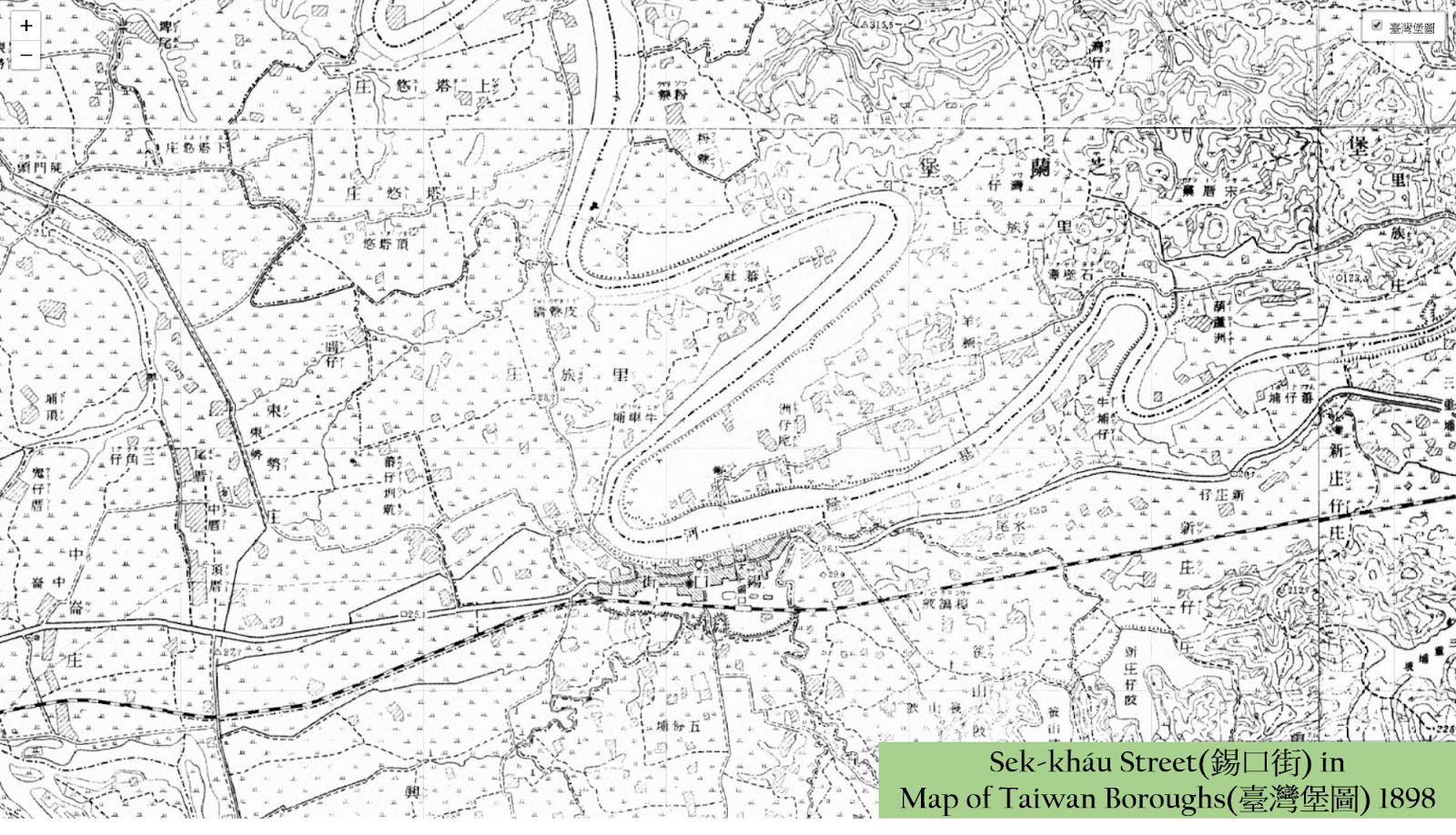
Figure 9: The name of Sek-kháu seen in 1898 release of the first land survey of Taiwan Boroughs. The town was called Sek-kháu street(錫口街). Source: Taipei Historic Map Archives 中研院台灣百年歷史地圖 http://gissrv4.sinica.edu.tw/gis/twhgis/
There are few places of Sek-kháu
period of the town still survive until today. The earliest one is the Matsu
temple which was first laid in 1753 as the Sek-kháu Matsu Temple (錫口媽祖廟).

Figure 10: The Matsu Temple during a facelift in 1949, captured by
photographer of American LIFE magazine. The temple has stood along the river (backward
looking) since mid 18th century as a result of the Han-Chinese
settlement to this upstream river port. The temple originally called Sek-kháu Matsu Temple before 1920. Source: LIFE

Figure 11: The taller growing Songshan Matsu Temple and the newly renovated campus building
of Songshan Primary School which can be traced back to 1898.
Another building that still survives through Sek-kháu period to modern Songshan period is the Sek-kháu
Marketplace (錫口市場) that was first built in 1909. This building also was renamed as Matsuyama
Public Market place after 1920. The marketplace was discovered during the
construction of the Songshan Metro system that intentionally to unblock that
old and derelict wooden marketplace until findings of the 1909 first build
timber and roof structure were identified. It was declared a listed Taipei
Historic Building in early 2000s by the city cultural authority.

Figure 12: The long building with additional roof along the
ridge in the central of this 1959 photo by Tom Jones is the Sek-kháu
Marketplace that still survives to these days as a listed heritage. Photo: Tom
Jones.
Starting
from second half of 19th century, red bricks began largely deployed in
Formosa as the building materials for residential townhouses and country farmhouses
in addition to the original bamboos mixed with straws and clays due to the
increased foreign missionary and trading influences brought to many of the port
towns. Starting from the 1895 Japanese Administration in Formosa since 1895,
the number of western style of red bricks kilns and ceramics plants grew significantly
along the rivers where it was easier to access to the water and clays and also river
as transport.

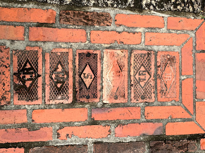 Figure 14: The engraving marks of TR or S on redbricks produced at Taiwan Renga Company and Samuel and Samuel Company around Sek-kháu area. These pieces were found in Tamsui's British Shell warehouses run by Huang Don-Mao who later become the largest shareholder after the merger in 1918. Photo by Willie Chen


Figure 13: The
twisted river section of river Keelung around Sek-kháu area. An American air force
veteran Tone Jones had a photo taken on a jet that seeing the river and
farmland areas(the green arrow) near Sek-kháu in 1959. He had incidentally
captured the first western ceramic plant and kilns (Samuel & Samuel Co)
along the river.
A
British merchant Samuel & Samuel Co. (撒木耳公司) set up a ceramics plant north of the
Sek-kháu market town facing the river Keelung in 1914. This plant was later
merged in 1918 by Taiwan Renga Company (台灣煉瓦株式會社) which was first setup earlier by
Japanese and had a fierce price competition with Samuel & Samuel Co.. The
kilns that were introduced during Japanese Administration period of Taiwan are
machinery production kilns which were devised by Hoffmann from German. Outskirt
of Sek-kháu market town along the river therefore became one of the major production
centers of fine western bricks in the early 20th century. It was
heard that those bricks to put up Taipei Presidential Palace (台灣總督府) came from one of the
kilns here.

The bricks produced by Taiwan Renga Co
feature an engraving print of “T.R.” on surface of every brick while Samuel
&Samuel Co had a “S” or reversed mark of “S.”. A successful Taiwanese tycoon
Huang Don-Mao (黃東茂) who enjoyed oil business in Tamsui
as an exclusive British Shell Oil agent in Formosa became the largest
shareholder of Taiwan Renga company after the merger of Samuel & Samuel Co.
He had also run a famous restaurant in Dadoacheng borough called Penlai Courthouse (蓬萊閣) which later defined the finest culinary of the upper
class in Taipei. The fortune came from the upstream river Keelung for the Coal
Mine and camphor trading at Sek-kháu together with leading productions of
bricks and ceramics through machinery kilns further pushed this market town in an
ever opulent century.

Figure 15: The
magnificent Penlai Courthouse Restaurant in Dadaocheng area, one of the top
notch restaurants in early 20th century Taipei opened by successful
oil and red brick tycoon of Tamsui. The photo was taken by USA air force
officer Don Irwin in his stay around 1955.

Figure 16: The
kilns in the west and outskirt of the Sek-kháu market town that still survives
today in 2019. Photo in 1969 taken by George Lane and Lt Carroll Nick Merydith.
Between 1910s to 1960s it was seen the
highest amount of the brick kilns erected near the Sek-kháu. During an
industrial past of the east town Taipei from Songshan to Nangang, the air could
be fairly polluted as seen in many photos before 1970s and areas of Taipei in
the very east is called Blacken County (黑鄉) which had a
notion to describe the heavy industrial past. After 1970s when Taiwan had started
deployed concrete and reinforced cement for building taller modern condos and
offices, it started to see a dramatic decline for the area’s economics from
ceramics production and also a rising demand for better living condition urged
in the east side of Taipei when more people move in to develop farmland into
residential blocks.

Figure 17: The riverside area
of former Sek-kháu as seen with smoking
kilns along
the train route and closer to Songshan Primary School separated
by a river ditch in 1969 photo captured by the American Airforce.
Photo credit- George-Lane and Carroll Nick Merydith.
The economics boom of Sek-kháu maket town largely bets on the river ferry in the middle section of the River Keelung since mid 18th century. When the first public ferry route with a printed ticket reused from London Print House during 1888, yet another means of public transportation also emmerged. The railway route from Sek-kháu to Taipei walled city was announced in the same year with operation began in the following year. The location of the train station in Sek-kháu changed many times in two centuries. The very formal timber train station was laid in 1911 as Sek-kháu Railway Stop (錫口停車場), expanded in 1940 and finally survived through 1985 when the train routes in Taiwan were upgraded for electric trains. The rise of the train routes linked island wide during 1970s had brought reduction in the ferry for Sek-kháu as a port town. This was another reason Sek-kháu grew less dependent for the economic success from the former commodities.

Taipei rose to a municipal city status
and got expanded eastward in 1967, Songshan(formerly Sek-kháu) and heavily industrialized
Nangang towns were merged into eastern districts of Taipei city. This had revolutionised
the population landscape ever since while the formerly farmlands south of the
railway track in Songshan were redeveloped into residential neighborhoods. A
burgeoning class of new citizens gradually changed the market towns.

Figure 19:
Another financial institution that was born with name of Sek-kháu in 1919 as
the Farmer Co-op. The buildings were all gone in early 2010s for high rising
hotel and office.
Another building that also underwent and
witnessed three periods naming of this place is Sek-kháu Farmer Co-operative
society (錫口信用組合) which was opened in 1919 and renamed to Matsuyama Farmer Co-op (松山農會) in the
following year. A magnificent two story tall bank with Art-Deco gable wall design and an arcaded
façade Barn were built near to the newly built wooden train station. The barn building
was once a dominating architecture of the area and faced the massive Sek-kháu
Marketplace built in 1909. The barn structure was knocked down in 1970s for an
office block leaving the adjacent bank building surviving through early 2010s
for another high rising hotel office complex. These two buildings are the testimony
of the areas of the success and transformation of the market town economics and
transition from the farming past of East Taipei at Sek-kháu.
Authored by Willie Chen
First edited on 2019-12-19
New edits on 209-12-24 for paragraphs in blue.
4. 松山火車站
5. 台灣煉瓦株式會社松山工場
Possible another shot for Samuel & Samuel Kilns and Ceramic Factory was taken by Toa-Tiu-Ti born photographer, Deng Nan Kuan (鄧南光), during 1942-45. He took this through the Tori of Taiwan State Shrine. https://www.facebook.com/photo?fbid=1455953614586084&set=pcb.1455957434585702
ReplyDelete